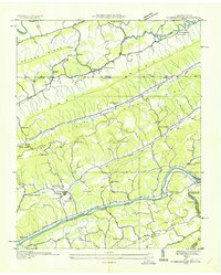
1935 Map of Sneedville
USGS Topo · Published 1935About this map
Sneedville serves as the focal point of this 1935 survey, situated at the confluence of Rock Creek and Greasy Creek just north of the Clinch River. The map illustrates a landscape shaped by parallel ridges, including Wallen Ridge and Newman Ridge, which dictate the paths of early roads and small agricultural settlements. The rural infrastructure of the era is evident through a high density of named educational and religious institutions, such as Vardy Community Sch and Ferguson Chapel Sch, reflecting the community-centric organization of eastern Tennessee before significant modernization. Downriver, industrial footprints appear with the Pressmens Union Power Plant and a corresponding Dam, highlighting the early electrification efforts along the river. This survey also records the presence of CCC Camp No 26, a marker of Depression-era public works projects active in the Clinch River valley during the mid-1930s.
Find a feature on this map
69 named features on this map. Tap any name to fly to it.
Don’t see what you’re looking for? This feature index may not catch every label — zoom into the map to look around manually.
Map Details
Editions of this 1935 Sneedville Map
This is the sole edition of this map. No revisions or reprints were ever made.
Other maps of this area

1883 · Morristown
USGS Topo · 1:125,000

1887 · Jonesville
USGS Topo · 1:125,000

1891 · Jonesville
USGS Topo · 1:125,000

1893 · Morristown
USGS Topo · 1:125,000

1895 · Morristown
USGS Topo · 1:125,000

1932 · Hagan
USGS Topo · 1:62,500

1935 · Rogersville
USGS Topo · 1:48,000

1935 · Tate Springs
USGS Topo · 1:48,000

1935 · Kyles Ford
USGS Topo · 1:24,000

1935 · Lee Valley
USGS Topo · 1:24,000