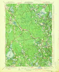
1942 Map of Snipatuit Pond
USGS Topo · Published 1942About this map
Snipatuit Pond and its surrounding wetlands anchor this 1942 study of the borderlands between Middleborough and Rochester. The landscape is defined by its industrial agricultural roots, specifically the numerous cranberry bogs such as Atwood Bogs, Benson Pond Bogs, and Stewart Bog that dot the low-lying terrain. These systems are connected by a network of watercourses including Rocky Gutter Brook and the Mattapoisett River, illustrating how the natural hydrology was managed for local industry during the early 20th century.
Find a feature on this map
119 named features on this map. Tap any name to fly to it.
Don’t see what you’re looking for? This feature index may not catch every label — zoom into the map to look around manually.
Map Details
Editions of this 1942 Snipatuit Pond Map
3 editions found
Other maps of this area

1885 · New Bedford
USGS Topo · 1:62,500

1885 · Middleboro
USGS Topo · 1:62,500

1886 · Falmouth
USGS Topo · 1:62,500

1886 · Plymouth
USGS Topo · 1:62,500

1888 · New Bedford
USGS Topo · 1:62,500

1888 · Falmouth
USGS Topo · 1:62,500

1888 · Middleboro
USGS Topo · 1:62,500

1889 · Plymouth
USGS Topo · 1:62,500

1893 · Middleboro
USGS Topo · 1:62,500

1893 · Falmouth
USGS Topo · 1:62,500