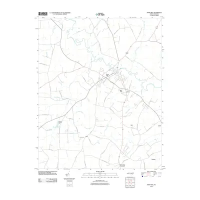
2010 Map of Snow Hill
USGS Topo · Published 2010About this map
Snow Hill serves as the central hub of this coastal plain landscape, situated along the winding banks of Contentnea Creek. The area is defined by a dense network of agricultural roads and low-lying wetlands, including Tyson Marsh and the many branches feeding into the creek. Several distinct local settlements are documented, from Arba and Hill View to the more outlying Glenfield and Browntown Crossroads. A clear intersection of industrial and natural history is visible at the Turnage Millpond, where the Turnage Millpond Dam regulates the water. For researchers, the presence of the Snow Hill Cemetery and Rainbow Cemetery, along with rail-adjacent landmarks like Suggs Siding, provides a clear view of the community's established infrastructure and ancestral footprint in Greene County during this period.
Find a feature on this map
66 named features on this map. Tap any name to fly to it.
Don’t see what you’re looking for? This feature index may not catch every label — zoom into the map to look around manually.
Map Details
Editions of this 2010 Snow Hill Map
This is the sole edition of this map. No revisions or reprints were ever made.
Other maps of this area

1904 · Falkland
USGS Topo · 1:62,500

1904 · Wilson
USGS Topo · 1:62,500

1914 · Kinston
USGS Topo · 1:48,000

1916 · Kinston
USGS Topo · 1:62,500

1953 · Rocky Mount
USGS Topo · 1:250,000

1954 · Rocky Mount
USGS Topo · 1:250,000

1957 · Goldsboro
USGS Topo · 1:62,500
1978 · Stantonsburg
USGS Topo · 1:24,000
1981 · Farmville
USGS Topo · 1:24,000
1981 · Walstonburg
USGS Topo · 1:24,000