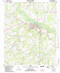
1982 Map of Snow Hill
USGS Topo · Published 1983About this map
Contentnea Creek winds through the heart of Greene County, serving as the primary geographical anchor for the town of Snow Hill. During the early 1980s, this area retained its rural character, defined by a network of drainage basins including Tyson Marsh, Beargarden, and the Pocosin. The landscape is dotted with small agricultural hubs and family-named localities like Arba, Bests, and Crews. Local history is deeply embedded in the numerous rural sanctuaries such as McCoy Chapel, Branch Grove Ch, and Jerusalem Ch. The presence of the Turnage Millpond on Tyson Creek suggests a legacy of local water-powered industry, while the Lenoir Community Col indicates the town's role as a regional educational center. Transport and infrastructure are represented by the Armory in town and a scattered network of roads connecting crossroads like Browntown Crossroads.
Find a feature on this map
57 named features on this map. Tap any name to fly to it.
Don’t see what you’re looking for? This feature index may not catch every label — zoom into the map to look around manually.
Map Details
Editions of this 1982 Snow Hill Map
This is the sole edition of this map. No revisions or reprints were ever made.
Other maps of this area

1904 · Falkland
USGS Topo · 1:62,500

1904 · Wilson
USGS Topo · 1:62,500

1914 · Kinston
USGS Topo · 1:48,000

1916 · Kinston
USGS Topo · 1:62,500

1953 · Rocky Mount
USGS Topo · 1:250,000

1954 · Rocky Mount
USGS Topo · 1:250,000

1957 · Goldsboro
USGS Topo · 1:62,500
1978 · Stantonsburg
USGS Topo · 1:24,000
1981 · Farmville
USGS Topo · 1:24,000
1981 · Walstonburg
USGS Topo · 1:24,000