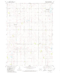
1980 Map of Snow Lake
USGS Topo · Published 1980About this map
Small rural schoolhouses and local cemeteries define this late 20th-century landscape in Brule County, South Dakota. The prairie is divided into several distinct townships, including Highland, Wilbur, and Pleasant Grove, each serving as a center for the farming community. Local life is anchored by institutions like the Highland Sch and the Pleasant Grove Ch, while family history is recorded at Gabrielson Cem and Pleasant Grove Cem. Numerous depressions and wetlands characterize the terrain, protected in part by the National Waterfowl Production Area. These seasonal and permanent water bodies, such as Snow Lake and Torrey Lake, indicate a region where the water table and natural drainage patterns were central to land use and conservation efforts before the turn of the century.
Find a feature on this map
12 named features on this map. Tap any name to fly to it.
Don’t see what you’re looking for? This feature index may not catch every label — zoom into the map to look around manually.
Map Details
Editions of this 1980 Snow Lake Map
This is the sole edition of this map. No revisions or reprints were ever made.
Other maps of this area

1955 · Mitchell
USGS Topo · 1:250,000

1959 · Mitchell
USGS Topo · 1:250,000

1971 · Academy
USGS Topo · 1:24,000

1979 · Bijou Hills NE
USGS Topo · 1:24,000

1979 · Cedar Grove Colony
USGS Topo · 1:24,000

1979 · Eagle
USGS Topo · 1:24,000

1979 · Platte Lake
USGS Topo · 1:24,000

1979 · Lake George
USGS Topo · 1:24,000
1979 · Platte
USGS Topo · 1:24,000

1979 · Kimball South
USGS Topo · 1:24,000
Featured Places
- Pleasant Grove Township, SD
- Wilbur Township, SD
- Highland Township, SD
- Torrey Lake Township, SD
- Brule County, SD