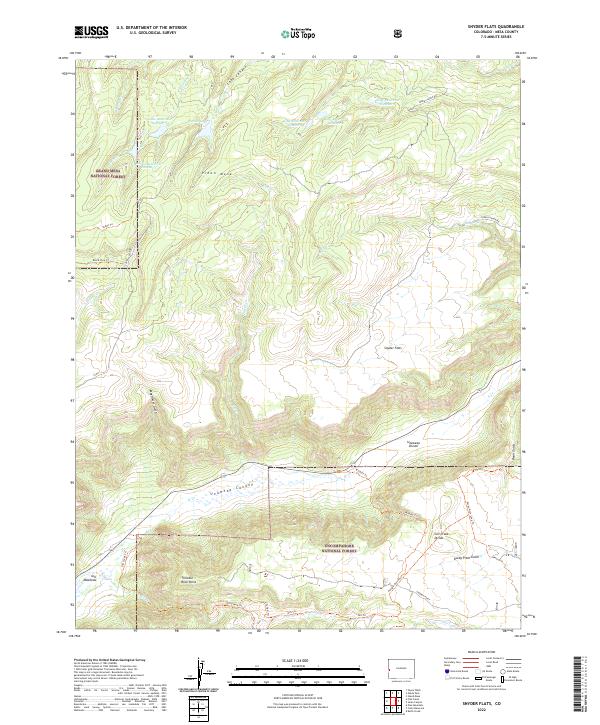
2022 Map of Snyder Flats
USGS Topo · Published 2022About this map
Piñon Mesa rises as a prominent high-altitude plateau, characterized by a complex system of water management and drainage. The northern reaches are dotted with historical infrastructure such as Gobbo Reservoir Number 1 and King Reservoir Number 1, alongside Enochs Lake, suggesting a landscape shaped by both natural basins and seasonal water storage. To the south, the dramatic transition into Unaweep Canyon is marked by the Unaweep Divide, a rare geologic feature where drainage splits in opposite directions from a single canyon floor.
Find a feature on this map
43 named features on this map. Tap any name to fly to it.
Don’t see what you’re looking for? This feature index may not catch every label — zoom into the map to look around manually.
Map Details
Editions of this 2022 Snyder Flats Map
This is the sole edition of this map. No revisions or reprints were ever made.
Other maps of this area

1950 · Pine Mountain
USGS Topo · 1:24,000

1956 · Moab
USGS Topo · 1:250,000

1959 · Moab
USGS Topo · 1:250,000

1960 · Moab
USGS Topo · 1:250,000
1960 · Gateway
USGS Topo · 1:62,500
1960 · Pine Mountain
USGS Topo · 1:24,000

1962 · Moab
USGS Topo · 1:250,000

1964 · Moab
USGS Topo · 1:250,000

1965 · Moab
USGS Topo · 1:250,000
1969 · Glade Park
USGS Topo · 1:24,000