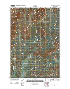
2011 Map of Soapstone Lake
USGS Topo · Published 2011About this map
Aldervale sits at the southern edge of this coastal range landscape, positioned where Northfork RD meets the winding North Fork Nehalem River. The terrain is defined by a dense network of drainage systems, including Little Rackheap Creek and Big Rackheap Creek, which carve through the high ground between Sugarloaf Mountain and Black Butte. To the east, the flat expanse of Gods Valley provides a striking contrast to the surrounding ridges, served by the long reach of Gods Valley RD. This 2011 survey documents a region dominated by timber land and narrow river valleys, where small water bodies like Soapstone Lake and Grassy Lake are tucked away in the higher elevations. The map provides a clear record of the access roads used to navigate these peaks, such as Buchanan Creek RD and Cole Mountain RD, tracing the infrastructure of the Oregon Coast Range.
Find a feature on this map
37 named features on this map. Tap any name to fly to it.
Don’t see what you’re looking for? This feature index may not catch every label — zoom into the map to look around manually.
Map Details
Editions of this 2011 Soapstone Lake Map
This is the sole edition of this map. No revisions or reprints were ever made.
Other maps of this area

1937 · Nehalem
USGS Topo · 1:62,500

1937 · Enright
USGS Topo · 1:62,500

1939 · Saddle Mountain
USGS Topo · 1:62,500

1940 · Cape Falcon
USGS Topo · 1:62,500

1941 · Enright
USGS Topo · 1:62,500

1943 · Nehalem
USGS Topo · 1:62,500

1943 · Saddle Mtn.
USGS Topo · 1:62,500

1948 · Vancouver
USGS Topo · 1:250,000

1949 · Tillamook Head
USGS Topo · 1:24,000

1950 · Vancouver
USGS Topo · 1:250,000