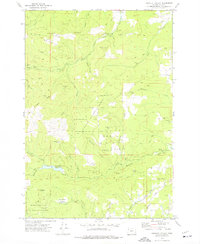
1973 Map of Socialist Valley
USGS Topo · Published 1977About this map
Socialist Valley sits at the heart of this timber and watershed region in the early 1970s, surrounded by the managed lands of the Siuslaw National Forest and the George T Gerlinger State Experimental Forest. The landscape is defined by the high terrain of Mill Creek Ridge and Mt Brown, where numerous resource extraction points like Borrow Pits and Quarries dot the hillsides. A network of primitive Jeep Trails and forest roads, including Robb Road and Oakdale Road, connects these remote areas to more established sites like the Old German Brethren Ch near the map's eastern edge.
Find a feature on this map
45 named features on this map. Tap any name to fly to it.
Don’t see what you’re looking for? This feature index may not catch every label — zoom into the map to look around manually.
Map Details
Editions of this 1973 Socialist Valley Map
This is the sole edition of this map. No revisions or reprints were ever made.
Other maps of this area

1922 · Airlie
USGS Topo · 1:31,680

1942 · Sheridan
USGS Topo · 1:62,500

1942 · Spirit Mtn
USGS Topo · 1:62,500

1942 · Valsetz
USGS Topo · 1:62,500

1942 · Dallas
USGS Topo · 1:62,500

1948 · Vancouver
USGS Topo · 1:250,000

1950 · Vancouver
USGS Topo · 1:250,000

1950 · Vancouver
USGS Topo · 1:250,000

1953 · Salem
USGS Topo · 1:250,000

1954 · Salem
USGS Topo · 1:250,000