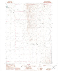
1982 Map of Sod House
USGS Topo · Published 1982About this map
The Kings River Valley and the northern reaches of the Double H Mountains define this high desert landscape in Humboldt County. The namesake Sod House settlement and nearby Sod House Point sit along the banks of the Quinn River, which meanders through a valley characterized by its remote ranching and water infrastructure. The map documents an era of resource management, featuring the Sod House-Quinn River Well and the whimsically named Gone With The Wind Well. To the northwest, the corner of the Fort McDermitt Indian Reservation overlaps the terrain near the Quinn River Lakes. Notable landmarks such as Riverside Ranch and a Radio Facility illustrate the sparse but essential points of human activity in this arid basin, while features like Moonshine Canyon and Cheuetto Spring mark the rugged interior of the mountain range.
Find a feature on this map
29 named features on this map. Tap any name to fly to it.
Don’t see what you’re looking for? This feature index may not catch every label — zoom into the map to look around manually.
Map Details
Editions of this 1982 Sod House Map
This is the sole edition of this map. No revisions or reprints were ever made.
Other maps of this area

1882 · Paradise
USGS Topo · 1:250,000

1886 · Disaster
USGS Topo · 1:250,000

1893 · Paradise
USGS Topo · 1:250,000

1893 · Disaster
USGS Topo · 1:250,000

1954 · Vya
USGS Topo · 1:250,000

1955 · McDermitt
USGS Topo · 1:250,000

1958 · Vya
USGS Topo · 1:250,000

1958 · Awakening Peak
USGS Topo · 1:62,500

1959 · McDermitt
USGS Topo · 1:250,000

1959 · Orovada
USGS Topo · 1:62,500