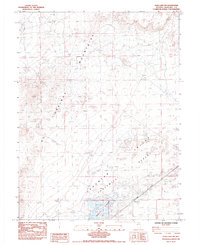
1985 Map of Soda Lake NW
USGS Topo · Published 1985About this map
Hot Springs Mountains dominate the western terrain of this Churchill County landscape, characterized by numerous Prospect sites and expansive Sand Dunes. The eastern half of the map gives way to the lower elevations of the Fortymile Desert and the La Hontan Valley, where the environment shifts from high ridges to arid flats. Industrial and agricultural utility is evident in the scattered Gravel Pits, Borrow Pits, and a lone Corral positioned near the desert floor.
Find a feature on this map
14 named features on this map. Tap any name to fly to it.
Don’t see what you’re looking for? This feature index may not catch every label — zoom into the map to look around manually.
Map Details
Editions of this 1985 Soda Lake NW Map
This is the sole edition of this map. No revisions or reprints were ever made.
Other maps of this area

1890 · Wadsworth
USGS Topo · 1:125,000

1892 · Wadsworth
USGS Topo · 1:125,000

1894 · Wadsworth
USGS Topo · 1:125,000

1908 · Carson Sink
USGS Topo · 1:250,000

1910 · Carson Sink
USGS Topo · 1:250,000

1951 · Soda Lake
USGS Topo · 1:62,500

1951 · Desert Peak
USGS Topo · 1:62,500

1957 · Fireball Ridge
USGS Topo · 1:62,500

1957 · Two Tips
USGS Topo · 1:62,500

1957 · Reno
USGS Topo · 1:250,000