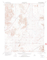
1956 Map of Soda Lake
USGS Topo · Published 1978About this map
Soda Lake dominates this arid landscape, a vast alkaline basin where water and geography shaped human movement through the Mojave Desert. In the mid-1950s, the Union Pacific corridor provided the primary transit link, passing through small outposts like Crucero and Balch. The presence of an Old Railroad Grade running north toward Tidewater reflects the shifting infrastructure of the era, marking the routes of earlier mining or transport efforts that once relied on water sources like Soda Springs (Alkali).
Find a feature on this map
21 named features on this map. Tap any name to fly to it.
Don’t see what you’re looking for? This feature index may not catch every label — zoom into the map to look around manually.
Map Details
Editions of this 1956 Soda Lake Map
3 editions found
Other maps of this area

1910 · Ivanpah
USGS Topo · 1:250,000

1912 · Ivanpah
USGS Topo · 1:250,000

1933 · Avawatz Mountains
USGS Topo · 1:250,000

1942 · Ivanpah
USGS Topo · 1:250,000

1942 · Amboy
USGS Topo · 1:250,000

1943 · Amboy
USGS Topo · 1:250,000

1947 · Trona
USGS Topo · 1:250,000

1947 · Kingman
USGS Topo · 1:250,000

1948 · Kingman
USGS Topo · 1:250,000

1948 · Red Pass Lake
USGS Topo · 1:62,500