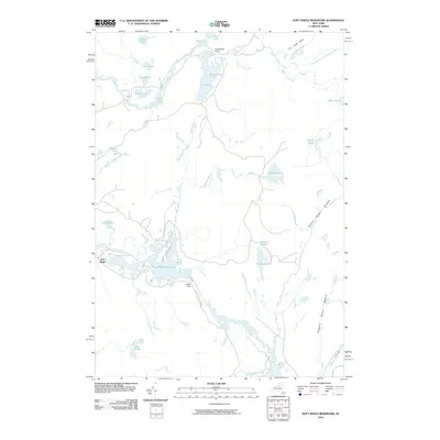
2010 Map of Soft Maple Reservoir
USGS Topo · Published 2010About this map
Soft Maple Reservoir dominates the lower central portion of this landscape, fed by the winding Beaver River. The surrounding terrain is characterized by a complex network of waterways, including the West Branch Oswegatchie River and a series of smaller bodies such as Lanes Pond, Twin Ponds, and Clear Pond. This 2010 survey shows the quiet development of the Oswegatchie Camp in the north and the small settlement of Soft Maple near the reservoir's western edge. Local history is etched into the names of the natural features, from the low ridge known as The Hogs Back to distinctive marshy areas like Cowboy Beaver Meadow and Threemile Beaver Meadow. The presence of Eagle Falls just below the reservoir dam highlights the area's hydroelectric and river management history along this stretch of the Beaver River system.
Find a feature on this map
33 named features on this map. Tap any name to fly to it.
Don’t see what you’re looking for? This feature index may not catch every label — zoom into the map to look around manually.
Map Details
Editions of this 2010 Soft Maple Reservoir Map
This is the sole edition of this map. No revisions or reprints were ever made.
Other maps of this area

1911 · Lowville
USGS Topo · 1:62,500

1912 · Number Four
USGS Topo · 1:62,500

1913 · Lowville
USGS Topo · 1:62,500

1913 · Lake Bonaparte
USGS Topo · 1:62,500

1915 · Number Four
USGS Topo · 1:62,500

1916 · Lake Bonaparte
USGS Topo · 1:62,500

1916 · Oswegatchie
USGS Topo · 1:62,500

1918 · Oswegatchie
USGS Topo · 1:62,500

1948 · Ogdensburg
USGS Topo · 1:250,000

1950 · Utica
USGS Topo · 1:250,000