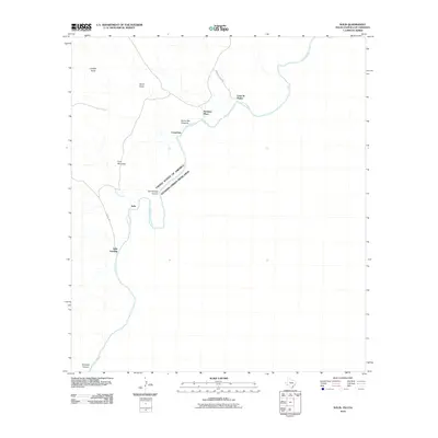
2010 Map of Solis
USGS Topo · Published 2010About this map
The Rio Grande marks the international boundary between the United States and Mexico in this sparse Chihuahuan Desert landscape. The map centers on the small settlement of Solis and nearby Solis Landing, where the river winds through steep terrain between San Vincent Canyon to the north and the dramatic Mariscal Canyon at the southern edge. The presence of family-named locations such as Rooneys Place and Comptons suggests a history of isolated ranching or riverside outposts connected by primitive routes like Casa de Piedra Rd. High desert peaks, including Sierra San Vincente and Iron Mountain, dominate the horizon above the river valley. Numerous dry washes, such as Fresno Creek, Juniper Draw, and Glenn Draw, feed toward the river, illustrating the drainage patterns of this arid borderland region during the early 21st century.
Find a feature on this map
16 named features on this map. Tap any name to fly to it.
Don’t see what you’re looking for? This feature index may not catch every label — zoom into the map to look around manually.
Map Details
Editions of this 2010 Solis Map
This is the sole edition of this map. No revisions or reprints were ever made.
Other maps of this area

1903 · Chisos Mountains
USGS Topo · 1:125,000

1905 · Chisos Mountains
USGS Topo · 1:125,000

1959 · Emory Peak
USGS Topo · 1:250,000

1965 · Emory Peak
USGS Topo · 1:250,000
1970 · Solis
USGS Topo · 1:24,000

1971 · Glenn Spring
USGS Topo · 1:24,000
1971 · Boquillas
USGS Topo · 1:24,000
1971 · San Vicente
USGS Topo · 1:24,000
1984 · Boquillas
USGS Topo · 1:100,000

1985 · Chisos Mountains
USGS Topo · 1:100,000