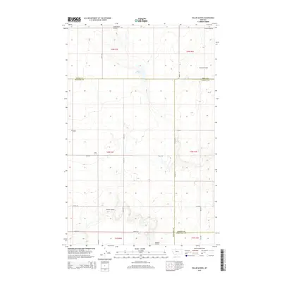
2014 Map of Sollid School
USGS Topo · Published 2014About this map
Sollid School and the Golden W Cem anchor this section of the Montana High Line where the borders of Chouteau, Pondera, Toole, and Liberty counties meet. The landscape is defined by the drainage patterns of the northern plains, featuring the Fowler Reservoir and the winding paths of Dead Indian Coulee and Pondera Coulee. The rectilinear road network, including family-named routes like Boyum Rd, Torske Rd, and Lytle Rd, reflects the enduring grid of agricultural section lines. These transport corridors connect isolated landmarks such as Shotgun Slough and Powder Coulee across the high prairie. The presence of St Olaf Church Rd in the north suggests the area's cultural heritage and the proximity of community gathering places that served the surrounding homesteads and farms in the early 21st century.
Find a feature on this map
31 named features on this map. Tap any name to fly to it.
Don’t see what you’re looking for? This feature index may not catch every label — zoom into the map to look around manually.
Map Details
Editions of this 2014 Sollid School Map
This is the sole edition of this map. No revisions or reprints were ever made.
Other maps of this area

1920 · Conrad
USGS Topo · 1:125,000

1954 · Shelby
USGS Topo · 1:250,000

1958 · Shelby
USGS Topo · 1:250,000

1967 · Central School
USGS Topo · 1:24,000
1967 · Fowler Coulee SE
USGS Topo · 1:24,000
1967 · Fowler Coulee NE
USGS Topo · 1:24,000

1970 · Knees NE
USGS Topo · 1:24,000

1970 · Knees
USGS Topo · 1:24,000

1970 · Sollid School
USGS Topo · 1:24,000

1970 · Pondera School
USGS Topo · 1:24,000