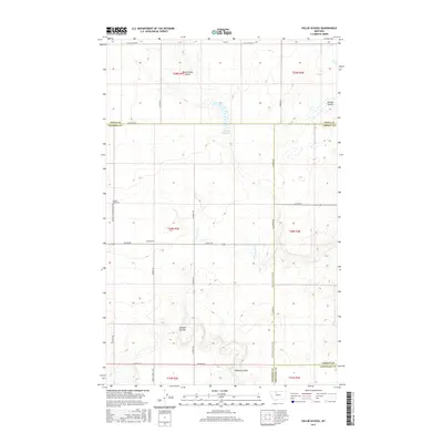
2017 Map of Sollid School
USGS Topo · Published 2017About this map
The northern Great Plains of Montana reveal a sparse, gridded landscape of agricultural endurance at the crossroads of four counties. Established on a high, wind-swept plateau, Sollid School and the St Olaf Church to the north represent the historic social anchors of this dry-land farming community. Water is a defining yet elusive feature of the terrain, marked by seasonal drainage patterns like Dead Indian Coulee, Powder Coulee, and Pondera Coulee. The presence of the Fowler Reservoir and Shotgun Slough highlights the vital importance of water management in a region where the land is divided by long, straight section-line roads such as Sollid Rd and Iverson Rd. Genealogists will find interest in the Golden West Cem, located along Golden W Cemetery Rd, which stands as a quiet record of the families who settled this high-prairie country.
Find a feature on this map
33 named features on this map. Tap any name to fly to it.
Don’t see what you’re looking for? This feature index may not catch every label — zoom into the map to look around manually.
Map Details
Editions of this 2017 Sollid School Map
This is the sole edition of this map. No revisions or reprints were ever made.
Other maps of this area

1920 · Conrad
USGS Topo · 1:125,000

1954 · Shelby
USGS Topo · 1:250,000

1958 · Shelby
USGS Topo · 1:250,000

1967 · Central School
USGS Topo · 1:24,000
1967 · Fowler Coulee SE
USGS Topo · 1:24,000
1967 · Fowler Coulee NE
USGS Topo · 1:24,000

1970 · Knees NE
USGS Topo · 1:24,000

1970 · Knees
USGS Topo · 1:24,000

1970 · Sollid School
USGS Topo · 1:24,000

1970 · Pondera School
USGS Topo · 1:24,000