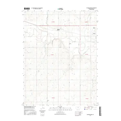
2015 Map of Solomon Rapids
USGS Topo · Published 2015About this map
Solomon River meanders across this Mitchell County landscape, defining the topography of the central and eastern sections near the settlement of Solomon Rapids. The area is characterized by its agricultural grid and numerous drainage systems, including Indian Cr and Browns Cr, which feed into the main river valley. Along the eastern edge, the western outskirts of Beloit are visible, featuring the Moritz Memorial Airport. Genealogists and local historians can locate long-established community landmarks such as Pleasant Valley Cem and Hopewell Cem, which are situated among the section lines and rural routes like W Main ST RD and Henry Trl. The map illustrates a typical Kansas prairie landscape where the natural curvature of the waterways contrasts sharply with the rigid township and range boundaries of t7s r8w and t7s r7w.
Find a feature on this map
31 named features on this map. Tap any name to fly to it.
Don’t see what you’re looking for? This feature index may not catch every label — zoom into the map to look around manually.
Map Details
Editions of this 2015 Solomon Rapids Map
This is the sole edition of this map. No revisions or reprints were ever made.
Other maps of this area

1894 · Mankato
USGS Topo · 1:125,000

1894 · Beloit
USGS Topo · 1:125,000

1953 · Solomon Rapids
USGS Topo · 1:24,000

1953 · Glen Elder South
USGS Topo · 1:24,000

1953 · Beloit
USGS Topo · 1:24,000

1955 · Beloit
USGS Topo · 1:250,000

1959 · Beloit
USGS Topo · 1:250,000

1962 · Jewell SE
USGS Topo · 1:24,000

1962 · Glen Elder North
USGS Topo · 1:24,000

1962 · Jewell SW
USGS Topo · 1:24,000