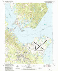
1987 Map of Solomons Island
USGS Topo · Published 1987About this map
The Naval Air Test Center (Patuxent River) dominates the southern shoreline where the Patuxent River meets the Chesapeake Bay in this late-1980s landscape. This military installation, featuring expansive runways and specialized facilities like the E Patuxent Basin, stands as a centerpiece of local defense activity. Across the water, the fishing and tourism character of Solomons and Olivet is evident, connected by the Thomas Johnson Bridge.
Find a feature on this map
82 named features on this map. Tap any name to fly to it.
Don’t see what you’re looking for? This feature index may not catch every label — zoom into the map to look around manually.
Map Details
Editions of this 1987 Solomons Island Map
This is the sole edition of this map. No revisions or reprints were ever made.
Other maps of this area

1892 · Leonardtown
USGS Topo · 1:62,500

1892 · Drum Point
USGS Topo · 1:62,500

1892 · Piney Point
USGS Topo · 1:62,500

1894 · Piney Point
USGS Topo · 1:62,500

1894 · Point Lookout
USGS Topo · 1:62,500

1895 · Leonardtown
USGS Topo · 1:62,500

1895 · Nomini
USGS Topo · 1:125,000

1895 · Piney Point
USGS Topo · 1:62,500

1898 · Nomini
USGS Topo · 1:125,000

1898 · St. Marys
USGS Topo · 1:125,000