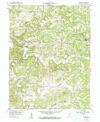
1956 Map of Solsberry
USGS Topo · Published 1990About this map
The town of Solsberry and the small settlements of Ridgeport and Park anchor this mid-century Greene County landscape, which is defined by the winding course of Richland Creek and its many tributaries. The Illinois Central railroad cuts across the terrain, passing just south of Solsberry and threading through the hills near Beech Creek. This survey captures a rural social fabric maintained by numerous neighborhood institutions, including the Combs Sch and several country churches such as Mt Calvary Ch and Sylvania Ch.
Find a feature on this map
39 named features on this map. Tap any name to fly to it.
Don’t see what you’re looking for? This feature index may not catch every label — zoom into the map to look around manually.
Map Details
Editions of this 1956 Solsberry Map
3 editions found
Other maps of this area

1908 · Bloomington
USGS Topo · 1:48,000

1908 · Bloomfield
USGS Topo · 1:62,500

1910 · Bloomington
USGS Topo · 1:62,500

1935 · Oolitic
USGS Topo · 1:48,000

1942 · Oolitic
USGS Topo · 1:62,500

1950 · Arney
USGS Topo · 1:24,000

1951 · Bloomfield
USGS Topo · 1:24,000

1953 · Indianapolis
USGS Topo · 1:250,000

1956 · Indianapolis
USGS Topo · 1:250,000

1956 · Freedom
USGS Topo · 1:24,000