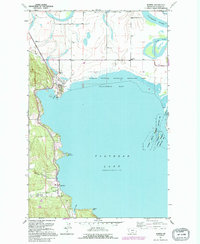
1991 Map of Somers
USGS Topo · Published 1995About this map
Somers and Lakeside anchor the northwestern shoreline of Flathead Lake, showing the transition from mid-century settlement patterns to the era of expanded conservation. The northern reaches of the map are defined by the winding course of the Flathead River and the complex wetlands of Fennon Slough, which feed into Kalispell Bay. This area includes the extensive Flathead National Waterfowl Production Area, highlighting the significance of this ecosystem for migratory birds.
Find a feature on this map
20 named features on this map. Tap any name to fly to it.
Don’t see what you’re looking for? This feature index may not catch every label — zoom into the map to look around manually.
Map Details
Editions of this 1991 Somers Map
This is the sole edition of this map. No revisions or reprints were ever made.
Other maps of this area

1920 · Flathead Lake
USGS Topo · 1:125,000

1943 · Kalispell
USGS Topo · 1:125,000

1956 · Wallace
USGS Topo · 1:250,000

1957 · Kalispell
USGS Topo · 1:250,000

1960 · Kalispell
USGS Topo · 1:250,000

1960 · Wallace
USGS Topo · 1:250,000

1961 · Kalispell
USGS Topo · 1:250,000

1962 · Lion Mountain
USGS Topo · 1:24,000

1962 · Somers
USGS Topo · 1:24,000

1962 · Creston
USGS Topo · 1:24,000