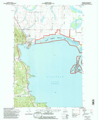
1994 Map of Somers
USGS Topo · Published 1995About this map
Flathead Lake dominates the southern landscape of this 1990s-era survey, where the north shore meets the delta of the Flathead River. The community of Somers sits prominently at the northwest corner of the lake, serving as a hub for both terrestrial and aquatic activity with its Somers Boat Launch and nearby Somers Sch. Along the western shoreline, the settlement of Lakeside is nestled near the mouth of Stoner Creek, marking a transition from the lower lake waters to the elevated terrain of the northwest.
Find a feature on this map
23 named features on this map. Tap any name to fly to it.
Don’t see what you’re looking for? This feature index may not catch every label — zoom into the map to look around manually.
Map Details
Editions of this 1994 Somers Map
This is the sole edition of this map. No revisions or reprints were ever made.
Other maps of this area

1920 · Flathead Lake
USGS Topo · 1:125,000

1943 · Kalispell
USGS Topo · 1:125,000

1956 · Wallace
USGS Topo · 1:250,000

1957 · Kalispell
USGS Topo · 1:250,000

1960 · Kalispell
USGS Topo · 1:250,000

1960 · Wallace
USGS Topo · 1:250,000

1961 · Kalispell
USGS Topo · 1:250,000

1962 · Lion Mountain
USGS Topo · 1:24,000

1962 · Somers
USGS Topo · 1:24,000

1962 · Creston
USGS Topo · 1:24,000