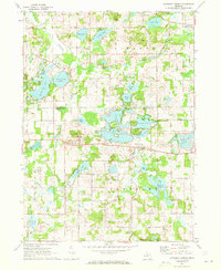
1971 Map of Somerset Center
USGS Topo · Published 1973About this map
Glacial lakes and small agricultural settlements define this section of the Michigan landscape on the Jackson and Hillsdale county line. The community of Somerset Center sits at a central crossroads near the northern tip of Somerset Lake, while further west, the village of Jerome is positioned along a former transit corridor. The industrial history of the area is visible through the Old Railroad Grade and several extractive sites, including Gravel Pits and the Putney Millpond. For those tracing local families, the map includes the Patch Cemetery, Aldrich Cemetery, and the East Liberty Church near the northern boundary. The terrain is notably water-rich, featuring a dense network of lakes such as Farewell Lake, Goose Lake, and Lake Le Ann, which indicate the region's development as a destination for recreation, further evidenced by the Deer Run Golf Club and a local County Park.
Find a feature on this map
54 named features on this map. Tap any name to fly to it.
Don’t see what you’re looking for? This feature index may not catch every label — zoom into the map to look around manually.
Map Details
Editions of this 1971 Somerset Center Map
2 editions found
Other maps of this area

1935 · Jackson
USGS Topo · 1:48,000

1939 · Jackson
USGS Topo · 1:62,500

1948 · Spring Arbor
USGS Topo · 1:62,500

1949 · Spring Arbor
USGS Topo · 1:62,500

1953 · Fort Wayne
USGS Topo · 1:250,000

1956 · Fort Wayne
USGS Topo · 1:250,000

1958 · Grand Rapids
USGS Topo · 1:250,000

1959 · North Adams
USGS Topo · 1:24,000

1961 · Grand Rapids
USGS Topo · 1:250,000

1962 · Grand Rapids
USGS Topo · 1:250,000