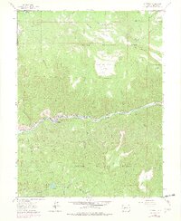
1964 Map of Somerset
USGS Topo · Published 1979About this map
Industrial operations along the North Fork Gunnison River dominate this landscape within the Gunnison National Forest. The settlement of Somerset serves as a central hub, where the Denver and Rio Grande Western railroad tracks parallel the river to support local resource extraction. Evidence of the region's mid-century energy economy is visible through the Oliver Power Plant, a nearby Filtration Plant, and several active coal works including the Bear Mine, Oliver Mine, and Clark Mine.
Find a feature on this map
39 named features on this map. Tap any name to fly to it.
Don’t see what you’re looking for? This feature index may not catch every label — zoom into the map to look around manually.
Map Details
Editions of this 1964 Somerset Map
4 editions found
Other maps of this area

1938 · Mt. Gunnison
USGS Topo · 1:48,000

1945 · Mount Gunnison
USGS Topo · 1:62,500

1956 · Montrose
USGS Topo · 1:250,000

1957 · Leadville
USGS Topo · 1:250,000

1959 · Leadville
USGS Topo · 1:250,000

1959 · Montrose
USGS Topo · 1:250,000

1960 · Leadville
USGS Topo · 1:250,000

1960 · Montrose
USGS Topo · 1:250,000

1961 · Electric Mountain
USGS Topo · 1:24,000

1962 · Leadville
USGS Topo · 1:250,000