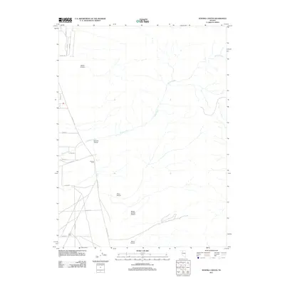
2011 Map of Sonoma Canyon
USGS Topo · Published 2011About this map
Sonoma Ranch and Valley Ranch serve as the primary human landmarks in this high-desert landscape of Humboldt County, Nevada. The terrain is defined by a series of drainage systems that descend toward the valley floor, including Sonoma Canyon, Mullen Canyon, and Willow Springs Canyon. These desert washes feed into Sonoma Creek, which winds through the central portion of the quadrangle. The road network indicates modern rural development, with clusters of residential streets like Sabian Ct and Reins Way appearing in the northwest corner. This infrastructure, along with arterial routes such as S Grass Valley Rd and Innean Rd, reveals how the area has transitioned from traditional ranching toward more contemporary residential use while maintaining its original geographic identity.
Find a feature on this map
21 named features on this map. Tap any name to fly to it.
Don’t see what you’re looking for? This feature index may not catch every label — zoom into the map to look around manually.
Map Details
Editions of this 2011 Sonoma Canyon Map
This is the sole edition of this map. No revisions or reprints were ever made.
Other maps of this area

1932 · Sonoma Range
USGS Topo · 1:250,000

1939 · Sonoma Range
USGS Topo · 1:250,000

1955 · Winnemucca
USGS Topo · 1:250,000

1958 · Winnemucca
USGS Topo · 1:250,000

1958 · Winnemucca
USGS Topo · 1:62,500

1958 · Rose Creek
USGS Topo · 1:62,500

1961 · Leach Hot Springs
USGS Topo · 1:62,500

1961 · Dun Glen
USGS Topo · 1:62,500

1962 · Winnemucca
USGS Topo · 1:250,000
1975 · Winnemucca NW
USGS Topo · 1:24,000