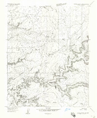
1955 Map of Sonsala Butte 3 NW
USGS Topo · Published 1958About this map
Canyon De Chelly National Monument reveals a landscape defined by deep sandstone incisions and significant archaeological sites within the Navajo Indian Reservation. This 1955 survey provides a look at the ancestral and contemporary Navajo presence on the Defiance Plateau before the widespread modernization of the late 20th century. Notable landmarks include the Navajo Fortress, Antelope House, and several complex cliff dwellings like the Battle Cove Ruins and Standing Cow Ruins. The map traces a network of unpaved routes, such as the Baby Foot Trail and various Jeep Trails, which served as the primary means of navigating the sheer-walled drainages of Canyon Del Muerto and Many Cherry Canyon. A centralized community point is established at the Canyon Del Muerto School, while numerous ruins and a Windmill indicate the localized patterns of residence and land use across the high plateau.
Find a feature on this map
31 named features on this map. Tap any name to fly to it.
Don’t see what you’re looking for? This feature index may not catch every label — zoom into the map to look around manually.
Map Details
Editions of this 1955 Sonsala Butte 3 NW Map
This is the sole edition of this map. No revisions or reprints were ever made.
Other maps of this area

1892 · Canyon De Chelly
USGS Topo · 1:250,000

1954 · Shiprock
USGS Topo · 1:250,000

1955 · Chinle 4 NE
USGS Topo · 1:24,000

1955 · Chinle 4 SE
USGS Topo · 1:24,000

1955 · Sonsala Butte 2 SW
USGS Topo · 1:24,000

1955 · Sonsala Butte 3 SE
USGS Topo · 1:24,000

1955 · Sonsala Butte 2 SE
USGS Topo · 1:24,000
1955 · Sonsala Butte 3 NE
USGS Topo · 1:24,000
1955 · Sonsala Butte 3 SW
USGS Topo · 1:24,000
1955 · Canyon Del Muerto
USGS Topo · 1:62,500
Featured Places
- Chinle Agency, AZ
- Junction Overlook, Chinle Agency
- Del Muerto, Chinle Agency
- Apache County, AZ
- United States