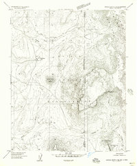
1955 Map of Sonsala Butte 4 NE
USGS Topo · Published 1958About this map
Upper Wheatfields serves as a focal point of settlement in this mid-century topographic survey, positioned near the waters of Wheatfields Creek. This portion of the Navajo Indian Reservation spans the high-elevation borderlands of Arizona and New Mexico, where the massive landforms of the Chuska Mountains dominate the eastern horizon. The landscape is defined by its water management and dramatic vertical relief, including a Dam at Wheatfields Lake and a Gaging Station downstream along Whiskey Creek. Geologic features such as the Beshlaht hdas Cliffs and the volcanic prominence of White Cone provide clear landmarks for the region. The map also records natural water sources like Bubbling Spring and the high-plateau Little White Cone Lake, reflecting the essential relationship between the seasonal drainage patterns and the local environment in the mid-1950s.
Find a feature on this map
21 named features on this map. Tap any name to fly to it.
Don’t see what you’re looking for? This feature index may not catch every label — zoom into the map to look around manually.
Map Details
Editions of this 1955 Sonsala Butte 4 NE Map
This is the sole edition of this map. No revisions or reprints were ever made.
Other maps of this area

1889 · Chaco
USGS Topo · 1:250,000

1892 · Chaco
USGS Topo · 1:250,000

1892 · Canyon De Chelly
USGS Topo · 1:250,000

1953 · Sanostee
USGS Topo · 1:62,500

1954 · Shiprock
USGS Topo · 1:250,000

1955 · Sonsala Butte 4 SE
USGS Topo · 1:24,000

1955 · Sonsala Butte 4 NW
USGS Topo · 1:24,000

1955 · Sonsala Butte 1 SE
USGS Topo · 1:24,000

1955 · Sonsala Butte 1 SW
USGS Topo · 1:24,000
1955 · Sonsala Butte 4 SW
USGS Topo · 1:24,000
Featured Places
- Shiprock Agency
- Chinle Agency, AZ
- Fort Defiance Agency
- Upper Wheatfields, Chinle Agency
- San Juan County, NM