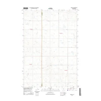
2015 Map of Sorum SW
USGS Topo · Published 2015About this map
The boundary between Harding Co and Perkins Co runs vertically through this portion of the South Dakota plains, defining a landscape of vast range land and intermittent watercourses. The drainage patterns are dictated by Antelope Creek, which meanders across the northern and central sections, while Ash Creek and Sheep Creek define the southern reaches. This modern survey reflects the enduring rural character of the region, where movement is facilitated by a sparse network of section-line roads and named routes. Local transportation is anchored by corridors such as Vernal Rd in the north and Marty Rd to the south, connecting remote ranching parcels. The map provides a clear look at the township and range system, showing the surveyed sections that still govern land ownership and use in this quiet corner of the Great Plains.
Find a feature on this map
15 named features on this map. Tap any name to fly to it.
Don’t see what you’re looking for? This feature index may not catch every label — zoom into the map to look around manually.
Map Details
Editions of this 2015 Sorum SW Map
This is the sole edition of this map. No revisions or reprints were ever made.
Other maps of this area

1935 · Hoover
USGS Topo · 1:125,000

1954 · Lemmon
USGS Topo · 1:250,000

1957 · Lemmon
USGS Topo · 1:250,000

1968 · Sheep Mountain
USGS Topo · 1:24,000

1968 · Flat Top Butte
USGS Topo · 1:24,000
1978 · Fish Draw
USGS Topo · 1:24,000

1980 · Redig
USGS Topo · 1:100,000

1980 · Zeona
USGS Topo · 1:25,000

1983 · Sorum NE
USGS Topo · 1:24,000
1983 · Sorum
USGS Topo · 1:24,000