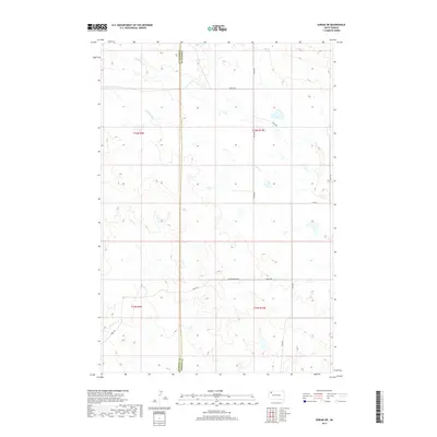
2017 Map of Sorum SW
USGS Topo · Published 2017About this map
The Harding County and Perkins County line divides this prairie landscape in the northwestern corner of South Dakota. The terrain is defined by the intermittent drainages of Antelope Cr, Ash Cr, and Sheep Cr, which carve subtle pathways through the open range. This 2017 survey reflects the enduring rural structure of the region, where a network of gravel and local roads provides access to isolated ranchlands and public grazing tracts. Long-established routes like Vernal Rd and Zeona Rd cross the section lines, maintaining connectivity in a territory shaped by the Public Land Survey System. The map provides clear documentation of the township and range boundaries, including t16n r10e and t15n r9e, essential for researchers tracing modern land ownership or historical land patents in these remote northwestern counties.
Find a feature on this map
14 named features on this map. Tap any name to fly to it.
Don’t see what you’re looking for? This feature index may not catch every label — zoom into the map to look around manually.
Map Details
Editions of this 2017 Sorum SW Map
This is the sole edition of this map. No revisions or reprints were ever made.
Other maps of this area

1935 · Hoover
USGS Topo · 1:125,000

1954 · Lemmon
USGS Topo · 1:250,000

1957 · Lemmon
USGS Topo · 1:250,000

1968 · Sheep Mountain
USGS Topo · 1:24,000

1968 · Flat Top Butte
USGS Topo · 1:24,000
1978 · Fish Draw
USGS Topo · 1:24,000

1980 · Redig
USGS Topo · 1:100,000

1980 · Zeona
USGS Topo · 1:25,000

1983 · Sorum NE
USGS Topo · 1:24,000
1983 · Sorum
USGS Topo · 1:24,000