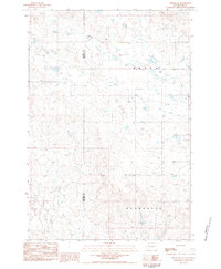
1983 Map of Sorum SW
USGS Topo · Published 1984About this map
Antelope Creek meanders through this portion of the northwestern South Dakota plains, defining a landscape of wide-ranging watercourses and subtle topographic shifts along the Harding Co Perkins Co border. This area within the Wells and Wyandotte townships reflects a late twentieth-century ranching and resource-based economy, where scattered wells and intermittent drainages like Ash Creek and Sheep Creek dominate the terrain. A notable geological landmark, Flat Butte, rises above the surrounding flats, serving as a primary navigational point in an otherwise open expanse. Industrial activity is localized at the Gravel Pits in the southwest, suggesting the extraction of materials for the regional road network. The map captures the infrastructure of the early 1980s, documenting a remote frontier where section lines and small-scale excavations represent the primary human imprint on the land.
Find a feature on this map
9 named features on this map. Tap any name to fly to it.
Don’t see what you’re looking for? This feature index may not catch every label — zoom into the map to look around manually.
Map Details
Editions of this 1983 Sorum SW Map
This is the sole edition of this map. No revisions or reprints were ever made.
Other maps of this area

1935 · Hoover
USGS Topo · 1:125,000

1954 · Lemmon
USGS Topo · 1:250,000

1957 · Lemmon
USGS Topo · 1:250,000

1968 · Sheep Mountain
USGS Topo · 1:24,000

1968 · Flat Top Butte
USGS Topo · 1:24,000
1978 · Fish Draw
USGS Topo · 1:24,000

1980 · Redig
USGS Topo · 1:100,000

1980 · Zeona
USGS Topo · 1:25,000

1983 · Sorum NE
USGS Topo · 1:24,000
1983 · Sorum
USGS Topo · 1:24,000