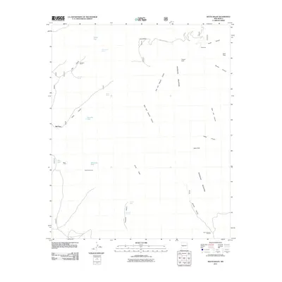
2011 Map of South Baldy
USGS Topo · Published 2011About this map
Magdalena Mountains dominate this high-elevation terrain, anchored by the prominent summit of South Baldy and the surrounding heights of Timber Peak and Italian Peak. The 2011 survey reveals a landscape where high-desert water sources are critical, marked by numerous isolated springs and catchment points such as Bear Canyon Spring, Pipeline Spring, and Horseshoe Tank. Human activity is sparse but distinct, centered on the historic cattle and timber operations at Muleshoe Ranch and Mill Place, connected by Water Canyon Rd. The complex drainage system is clearly defined by the deep incisions of Sawmill Canyon and Hardy Canyon, illustrating the rugged topography of the Cibola National Forest area. These canyons and peaks provided essential landmarks for ranching families and early foresters navigating the central New Mexico highlands.
Find a feature on this map
31 named features on this map. Tap any name to fly to it.
Don’t see what you’re looking for? This feature index may not catch every label — zoom into the map to look around manually.
Map Details
Editions of this 2011 South Baldy Map
This is the sole edition of this map. No revisions or reprints were ever made.
Other maps of this area

1954 · Tularosa
USGS Topo · 1:250,000

1954 · Socorro
USGS Topo · 1:250,000

1958 · Socorro
USGS Topo · 1:250,000

1958 · Tularosa
USGS Topo · 1:250,000

1959 · Magdalena
USGS Topo · 1:62,500

1962 · Socorro
USGS Topo · 1:250,000

1963 · Arroyo Landavaso
USGS Topo · 1:24,000
1965 · Tenmile Hill
USGS Topo · 1:24,000
1965 · Squaw Peak
USGS Topo · 1:24,000
1965 · Puertecito Gap
USGS Topo · 1:24,000