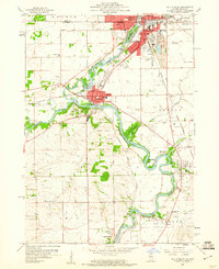
1959 Map of South Beloit
USGS Topo · Published 1960About this map
The Rock River dominates the geography of this northern Illinois borderland, winding south through South Beloit and Rockton just as the post-war industrial era was reshaping the valley. The convergence with the Pecatonica River and Turtle Creek highlights the importance of water and power to these communities, evidenced by the powerplant spillway and numerous gravel pits that underscore the local extraction industry. Cultural and educational life is represented through a dense network of rural schoolhouses, including the Sand Prairie Sch, Prairie Hill Sch, and Pleasant View Sch, many of which served the outlying agricultural townships of Owen and Harlem. Conservation efforts are already visible in the late 1950s with the establishment of the Macktown Forest Preserve and Hononegah Forest Preserve, protecting significant stretches of riverfront from the expanding residential footprints of Riverdale and Roscoe.
Find a feature on this map
52 named features on this map. Tap any name to fly to it.
Don’t see what you’re looking for? This feature index may not catch every label — zoom into the map to look around manually.
Map Details
Editions of this 1959 South Beloit Map
This is the sole edition of this map. No revisions or reprints were ever made.
Other maps of this area

1891 · Janesville
USGS Topo · 1:62,500

1893 · Janesville
USGS Topo · 1:62,500

1893 · Shopiere
USGS Topo · 1:62,500

1918 · Rockford
USGS Topo · 1:62,500

1918 · Belvidere
USGS Topo · 1:62,500

1938 · Rockford
USGS Topo · 1:62,500

1944 · Belvidere
USGS Topo · 1:62,500

1949 · Rockford
USGS Topo · 1:24,000

1954 · Rockford
USGS Topo · 1:250,000

1955 · Rockford
USGS Topo · 1:250,000