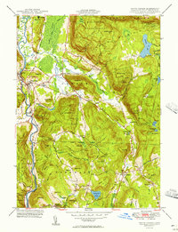
1950 Map of South Canaan
USGS Topo · Published 1957About this map
Falls Village serves as a primary western anchor for this mid-century survey, situated where the New York New Haven and Hartford railroad tracks follow the winding course of the Housatonic River. The landscape is defined by the heavy timber of the Housatonic State Forest and the scientific presence of the Yale University Forestry School near the eastern hills. Smaller crossroads and rural hamlets like South Canaan, Huntsville, and Cornwall Hollow are connected by a network of winding roads, while the Appalachian Trail traces a path across the heights of Music Mtn and Titus Mtn. For genealogists, the map is particularly helpful for locating rural burial sites such as St Patricks Cem, Sand Hill Cem, and Under Mountain Cem. The abundance of named peaks, including Bradford Mtn and Cobble Hill, illustrates the transition from river valley industry to highland conservation and education.
Find a feature on this map
63 named features on this map. Tap any name to fly to it.
Don’t see what you’re looking for? This feature index may not catch every label — zoom into the map to look around manually.
Map Details
Editions of this 1950 South Canaan Map
3 editions found
Other maps of this area

1885 · Sheffield
USGS Topo · 1:62,500

1888 · Sheffield
USGS Topo · 1:62,500

1888 · Sandisfield
USGS Topo · 1:62,500

1891 · Sheffield
USGS Topo · 1:62,500

1892 · Winsted
USGS Topo · 1:62,500

1892 · Cornwall
USGS Topo · 1:62,500

1893 · Sheffield
USGS Topo · 1:62,500

1893 · Cornwall
USGS Topo · 1:62,500

1893 · Sandisfield
USGS Topo · 1:62,500

1897 · Sandisfield
USGS Topo · 1:62,500