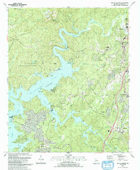
1993 Map of South Canton
USGS Topo · Published 1993About this map
Allatoona Lake and the winding Etowah River dominate the landscape of central Cherokee County, where the sprawling waters meet established industrial and residential corridors. This 1993 edition, revised from earlier aerial photography, captures the region during a period of significant suburban development south of the main Canton settlement. The map traces the CSX Transportation railroad line as it passes through North Canton, South Canton, and down toward Holly Springs, illustrating the historical transport spine of the area. Local genealogy is well-represented through numerous family and community landmarks, including Lovingood Cem, Sweetwater Ch Cem, and several historic houses of worship like Fields Chapel and Grace Ch. These sites, along with established landings such as Little River Landing, provide a detailed record of the community's evolution from a river-based economy to a modern lakeside and commuter hub.
Find a feature on this map
62 named features on this map. Tap any name to fly to it.
Don’t see what you’re looking for? This feature index may not catch every label — zoom into the map to look around manually.
Map Details
Editions of this 1993 South Canton Map
This is the sole edition of this map. No revisions or reprints were ever made.
Other maps of this area

1890 · Suwanee
USGS Topo · 1:125,000

1890 · Cartersville
USGS Topo · 1:125,000

1891 · Cartersville
USGS Topo · 1:125,000

1894 · Suwanee
USGS Topo · 1:125,000

1896 · Cartersville
USGS Topo · 1:125,000

1907 · Acworth
USGS Topo · 1:62,500

1909 · Acworth
USGS Topo · 1:62,500

1926 · Tate
USGS Topo · 1:62,500

1928 · Tate
USGS Topo · 1:62,500

1947 · Waleska
USGS Topo · 1:62,500