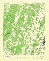
1935 Map of South Cleveland
USGS Topo · Published 1935About this map
White Oak Mountain and Lauderbach Ridge dominate the western landscape of this 1935 Tennessee Valley Authority and USGS survey, where the rural character of Bradley County is meticulously documented before significant modernization. The map captures a dense network of country schools and churches that served the agricultural community, including Hopewell Sch, White Oak Sch, and Philippi Ch. Of particular interest to local historians is the Pentecostal Orphans Home near the settlement of Harris.
Find a feature on this map
57 named features on this map. Tap any name to fly to it.
Don’t see what you’re looking for? This feature index may not catch every label — zoom into the map to look around manually.
Map Details
Editions of this 1935 South Cleveland Map
This is the sole edition of this map. No revisions or reprints were ever made.
Other maps of this area

1886 · Cleveland
USGS Topo · 1:125,000

1888 · Chattanooga
USGS Topo · 1:125,000

1892 · Cleveland
USGS Topo · 1:125,000

1893 · Chattanooga
USGS Topo · 1:125,000

1895 · Cleveland
USGS Topo · 1:125,000

1901 · Cleveland
USGS Topo · 1:125,000

1935 · East Cleveland
USGS Topo · 1:24,000

1935 · Mc Donald
USGS Topo · 1:24,000

1935 · Felker
USGS Topo · 1:24,000

1935 · Snow Hill
USGS Topo · 1:24,000