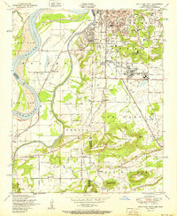
1951 Map of South Fort Smith
USGS Topo · Published 1951About this map
The Poteau River carves a winding path along the state border in the early 1950s, defining the landscape between Arkoma and the industrial outskirts of South Fort Smith. This survey captures the region's mid-century economic mix, from the heavy industry of the Zinc smelter and its Conveyor belt to the agricultural tracts of Paw Paw Bend. Local community life is deeply etched into the topography through a network of rural institutions, including St Scholastica Academy, the Cherry Grove Church, and numerous small schoolhouses like Peno School and Dunbar School. To the south, the terrain rises toward a series of prominent peaks including George Mountain and White Bluff Mountain, where the St Louis San Francisco railroad skirts the foothills near the settlement of Enterprise.
Find a feature on this map
54 named features on this map. Tap any name to fly to it.
Don’t see what you’re looking for? This feature index may not catch every label — zoom into the map to look around manually.
Map Details
Editions of this 1951 South Fort Smith Map
2 editions found
Other maps of this area

1879 · Fort Smith
USGS Topo · 1:62,500

1887 · Van Buren
USGS Topo · 1:62,500

1887 · Greenwood
USGS Topo · 1:62,500

1890 · Fort Smith
USGS Topo · 1:125,000

1900 · Sallisaw
USGS Topo · 1:125,000

1911 · Sallisaw
USGS Topo · 1:125,000

1943 · Fort Smith
USGS Topo · 1:125,000

1946 · Fort Smith
USGS Topo · 1:250,000

1947 · Van Buren
USGS Topo · 1:62,500

1947 · Greenwood
USGS Topo · 1:62,500