
1964 Map of South Haven NE
USGS Topo · Published 1966About this map
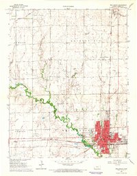
Slate Creek and its winding tributaries, including Antelope Creek and Snyder Creek, define the topography of this southern Kansas landscape during the mid-1960s. The region is largely organized by the township system, with boundaries for Avon, Greene, and Guelph overlaying a grid of section lines and rural homesteads. The modern infrastructure of the Kansas Turnpike cuts a bold north-south path through the center of the sheet, providing a sharp contrast to the established local landmarks. For those studying the social geography of the era, the map identifies several rural educational and community sites, such as Union Sch, Avon Sch, and Plainview Sch. Near the settlement of South Haven, the terrain transitions from the alluvial flats of the creeks to more complex contours, where scattered Gravel Pits and the Jordan Cem offer glimpses into the local industry and genealogy of Sumner County.
Find a feature on this map
21 named features on this map. Tap any name to fly to it.
Don’t see what you’re looking for? This feature index may not catch every label — zoom into the map to look around manually.
Map Details
Editions of this 1964 South Haven NE Map
This is the sole edition of this map. No revisions or reprints were ever made.
Other maps of this area

1890 · Wellington
USGS Topo · 1:125,000

1955 · Wichita
USGS Topo · 1:250,000

1958 · Wichita
USGS Topo · 1:250,000

1964 · Dalton
USGS Topo · 1:24,000

1965 · Portland
USGS Topo · 1:24,000

1965 · Adamsville
USGS Topo · 1:24,000

1965 · South Haven
USGS Topo · 1:24,000

1965 · Geuda Springs
USGS Topo · 1:24,000

1965 · Rome
USGS Topo · 1:24,000
1965 · Wellington
USGS Topo · 1:24,000