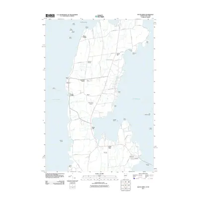
2011 Map of South Hero
USGS Topo · Published 2011About this map
South Hero Island and the neighboring islands of Lake Champlain are documented here in detail, showcasing the unique geography of the Champlain Islands at the start of the 2010s. The landscape is defined by its relationship to the water, where points like Nichols Point, Wilcox Point, and Jackson Point reach into the lake, and the Sand Bar Bridge provides a vital terrestrial link to the mainland. Settlements such as Grand Isle and South Hero anchor the island interior, while a network of rural roads like Quaker Rd and Pearl Rd connects scattered farmsteads and lakeshore camps.
Find a feature on this map
61 named features on this map. Tap any name to fly to it.
Don’t see what you’re looking for? This feature index may not catch every label — zoom into the map to look around manually.
Map Details
Editions of this 2011 South Hero Map
This is the sole edition of this map. No revisions or reprints were ever made.
Other maps of this area

1894 · Plattsburg
USGS Topo · 1:62,500

1895 · Rouse Point
USGS Topo · 1:62,500

1906 · Plattsburg
USGS Topo · 1:62,500

1907 · Rouse Point
USGS Topo · 1:62,500

1913 · Milton
USGS Topo · 1:48,000

1914 · St. Albans
USGS Topo · 1:48,000

1915 · Milton
USGS Topo · 1:62,500

1916 · St. Albans
USGS Topo · 1:62,500

1939 · Rouses Point
USGS Topo · 1:62,500

1939 · Plattsburg
USGS Topo · 1:62,500