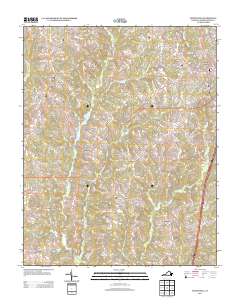
2013 Map of South Hill
USGS Topo · Published 2013About this map
South Hill serves as the primary urban center for this portion of Mecklenburg County, where a dense grid of streets like West Main Street and Goodes Ferry Road meet the regional transportation corridors of Highway 58 and Interstate 85. The surrounding countryside is characterized by numerous named crossroads and small rural communities that speak to the agricultural heritage of the Virginia Piedmont. Lombardy Grove and Smiths Crossroads anchor the central landscape, while smaller locales like Busy Bee Corner and Invermay mark the intersection of historic country routes. The terrain is defined by the drainage basins of Miles Creek and Flat Creek, with recreational and utilitarian water bodies like Lake Gordon and Pine Lake situated among the timbered tracts and fields. This map provides a detailed view of the modern infrastructure overlaid upon a traditional settlement pattern of hamlets such as Union Level and Redlawn.
Find a feature on this map
100 named features on this map. Tap any name to fly to it.
Don’t see what you’re looking for? This feature index may not catch every label — zoom into the map to look around manually.
Map Details
Editions of this 2013 South Hill Map
This is the sole edition of this map. No revisions or reprints were ever made.
Other maps of this area

1953 · Greensboro
USGS Topo · 1:250,000

1954 · Greensboro
USGS Topo · 1:250,000

1955 · Chase City
USGS Topo · 1:62,500

1955 · Kenbridge
USGS Topo · 1:62,500

1955 · Boydton
USGS Topo · 1:62,500

1962 · Greensboro
USGS Topo · 1:250,000

1966 · Greensboro
USGS Topo · 1:250,000
1966 · Wightman
USGS Topo · 1:24,000
1966 · North View
USGS Topo · 1:24,000
1966 · Forksville
USGS Topo · 1:24,000