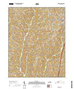
2019 Map of South Hill
USGS Topo · Published 2019About this map
South Hill and the surrounding agricultural landscape of Mecklenburg County are defined by a network of rural crossroads and long-established community landmarks. The settlement pattern here centers on small hubs like Union Level, Lombardy Grove, and Smiths Crossroads, which are linked by historic thoroughfares such as Plank Rd and the more modern transit corridor of Route 58. For those researching local family history, the map provides a wealth of data through its numerous burial grounds, including Saint Pauls Cem, Zion Cem, and the large Oakwood Cem in the northeastern corner. The drainage of the Piedmont terrain is clearly visible through the winding paths of Miles Cr and Flat Cr. Educational development is also noted with the presence of the Southside Virginia Community College Lake Country Advanced Knowledge Center, signaling the area's transition into a regional educational hub.
Find a feature on this map
98 named features on this map. Tap any name to fly to it.
Don’t see what you’re looking for? This feature index may not catch every label — zoom into the map to look around manually.
Map Details
Editions of this 2019 South Hill Map
This is the sole edition of this map. No revisions or reprints were ever made.
Other maps of this area

1953 · Greensboro
USGS Topo · 1:250,000

1954 · Greensboro
USGS Topo · 1:250,000

1955 · Chase City
USGS Topo · 1:62,500

1955 · Kenbridge
USGS Topo · 1:62,500

1955 · Boydton
USGS Topo · 1:62,500

1962 · Greensboro
USGS Topo · 1:250,000

1966 · Greensboro
USGS Topo · 1:250,000
1966 · Wightman
USGS Topo · 1:24,000
1966 · North View
USGS Topo · 1:24,000
1966 · Forksville
USGS Topo · 1:24,000