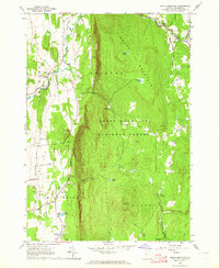
1963 Map of South Mountain
USGS Topo · Published 1964About this map
New Haven River winds through the northern valley of this landscape, anchoring the small communities of West Lincoln and New Haven Mills. The terrain is dominated by the steep western escarpment of the Green Mountain National Forest, where heights like South Mountain and The Cobble rise sharply above the agricultural lowlands of Bristol Flats. This mid-century survey reveals a network of rural roads such as Munger Street and Case Street, which connect several family and community burial grounds, including the Munger Street Cem and Riverside Cem. The infrastructure for local utilities is evident through the Middlebury Water Supply and the Middlebury Waterworks at the southern edge. Pockets of high-elevation water, like Abbey Pond and North Pond, sit within the heavily forested uplands, contrasting with the active Gravel Pits found along the valley floor.
Find a feature on this map
42 named features on this map. Tap any name to fly to it.
Don’t see what you’re looking for? This feature index may not catch every label — zoom into the map to look around manually.
Map Details
Editions of this 1963 South Mountain Map
3 editions found
Other maps of this area

1902 · Brandon
USGS Topo · 1:62,500

1903 · Middlebury
USGS Topo · 1:62,500

1904 · Brandon
USGS Topo · 1:62,500

1905 · Middlebury
USGS Topo · 1:62,500

1915 · Rochester
USGS Topo · 1:62,500

1917 · Rochester
USGS Topo · 1:62,500

1919 · Lincoln Mountain
USGS Topo · 1:62,500

1920 · Lincoln Mountain
USGS Topo · 1:48,000

1920 · Brandon
USGS Topo · 1:62,500

1920 · Middlebury
USGS Topo · 1:62,500