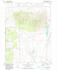
1993 Map of South Mountain
USGS Topo · Published 1993About this map
South Mountain dominates this portion of Tooele County, serving as a massive physical divider between the Tooele Valley to the north and the Rush Valley to the south. The landscape is a study in mid-century industrial and military utility, most notably defined by the sprawling footprint of the Tooele Army Depot at the northern edge. Resource extraction is evident throughout the terrain, with multiple Gravel Pits, a Quarry, and a Prospect scattered across the foothills and valley floors.
Find a feature on this map
19 named features on this map. Tap any name to fly to it.
Don’t see what you’re looking for? This feature index may not catch every label — zoom into the map to look around manually.
Map Details
Editions of this 1993 South Mountain Map
This is the sole edition of this map. No revisions or reprints were ever made.
Other maps of this area

1885 · Tooele Valley
USGS Topo · 1:250,000

1918 · Stockton
USGS Topo · 1:62,500

1953 · Tooele
USGS Topo · 1:250,000

1955 · Timpie
USGS Topo · 1:62,500

1955 · Deseret Peak
USGS Topo · 1:62,500

1955 · Grantsville
USGS Topo · 1:24,000

1955 · Stockton
USGS Topo · 1:62,500

1955 · Tooele
USGS Topo · 1:250,000

1955 · Tooele
USGS Topo · 1:24,000

1979 · Rush Valley
USGS Topo · 1:100,000