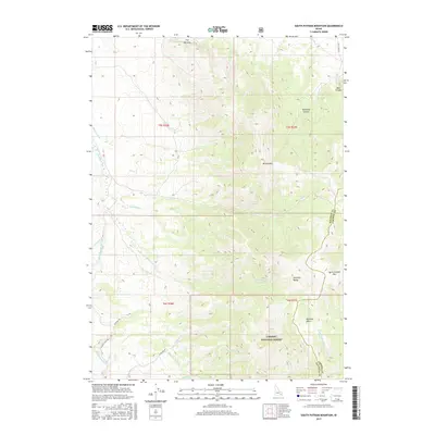
2017 Map of South Putnam Mountain
USGS Topo · Published 2017About this map
Mt Putnam and South Putnam Mtn dominate this high-elevation portion of the Portneuf Range along the boundary of Bannock and Caribou Counties. This 2017 survey details a landscape defined by significant drainage systems, including Ross Fork and its tributaries like the South Fork Ross Fork and Smoke Lateral. Much of the southern and eastern territory is occupied by the Caribou National Forest, where steep ridgelines give way to named topographic depressions like Buckskin Basin and Twitchell Canyon. Remote access is marked by several forest and ranch roads, including Jeff Cabin Rd and W McNabb Rd, which follow the contours of creeks such as McNabb Cr and Sawmill Cr. The presence of The Narrows along the northern reach of Ross Fork illustrates the constricted mountain passages characteristic of this Idaho backcountry.
Find a feature on this map
30 named features on this map. Tap any name to fly to it.
Don’t see what you’re looking for? This feature index may not catch every label — zoom into the map to look around manually.
Map Details
Editions of this 2017 South Putnam Mountain Map
This is the sole edition of this map. No revisions or reprints were ever made.
Other maps of this area

1937 · Pocatello
USGS Topo · 1:48,000

1940 · Blackfoot
USGS Topo · 1:62,500

1943 · Blackfoot
USGS Topo · 1:62,500

1944 · Pocatello
USGS Topo · 1:62,500

1954 · Pocatello
USGS Topo · 1:250,000

1955 · Yandell Springs
USGS Topo · 1:62,500

1955 · Idaho Falls
USGS Topo · 1:250,000

1958 · Idaho Falls
USGS Topo · 1:250,000

1958 · Pocatello
USGS Topo · 1:250,000

1968 · Bear Camp Gulch
USGS Topo · 1:24,000