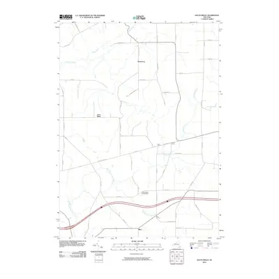
2010 Map of South Ripley
USGS Topo · Published 2010About this map
Wattlesburg and South Ripley anchor this rural landscape in southwestern New York, where agricultural patterns are defined by a network of drainage ways and locally named crossroads. The hydrology of the area is distinct, featuring the headwaters of Twentymile Creek flowing north toward Lake Erie, while the West Branch French Creek drains toward the south, illustrating the proximity to the continental divide. Small hamlets like Raters Corners and Sheldon Corners mark traditional gathering points in a township dominated by farm-to-market roads. The presence of Pratts Eastern Divide Airport and the Mina Cemetery near the settlement of Mina provides specific landmarks for genealogists and local historians tracing the development of Chautauqua County into the early 21st century.
Find a feature on this map
47 named features on this map. Tap any name to fly to it.
Don’t see what you’re looking for? This feature index may not catch every label — zoom into the map to look around manually.
Map Details
Editions of this 2010 South Ripley Map
This is the sole edition of this map. No revisions or reprints were ever made.
Other maps of this area

1899 · Westfield
USGS Topo · 1:62,500

1905 · Clymer
USGS Topo · 1:62,500

1913 · North East
USGS Topo · 1:62,500

1915 · North East
USGS Topo · 1:62,500

1939 · Clymer
USGS Topo · 1:62,500

1941 · Clymer
USGS Topo · 1:62,500

1943 · North East
USGS Topo · 1:62,500

1954 · South Ripley
USGS Topo · 1:24,000

1954 · Ripley
USGS Topo · 1:24,000
1954 · Clymer
USGS Topo · 1:24,000