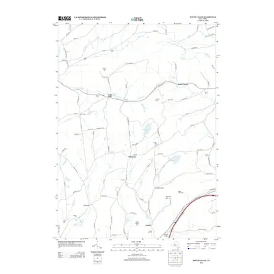
2013 Map of South Valley
USGS Topo · Published 2013About this map
South Valley and the surrounding hamlets of Decatur and Gothicville define the rural character of this Schoharie County landscape. The topography is marked by significant elevations like Elliot Hill and Stone Quarry Hill, while the drainage of Pleasant Brook and Decatur Cr cuts through the valleys. For family historians, the area is rich with small burial grounds, including the Sissum Cem, Winnie Cem, and Maple View Cem, many of which sit near historic farm roads. The presence of Furnaceville and Buttermilk Falls suggests a history of local industry and water power, while the eastern edge is defined by the winding course of Schenevus Cr. This survey captures a modern look at a region that maintains its traditional settlement patterns, centered on high ridges and tucked-away stream crossings.
Find a feature on this map
99 named features on this map. Tap any name to fly to it.
Don’t see what you’re looking for? This feature index may not catch every label — zoom into the map to look around manually.
Map Details
Editions of this 2013 South Valley Map
This is the sole edition of this map. No revisions or reprints were ever made.
Other maps of this area

1898 · Canajoharie
USGS Topo · 1:62,500

1900 · Canajoharie
USGS Topo · 1:62,500

1902 · Canajoharie
USGS Topo · 1:62,500

1903 · Richfield Springs
USGS Topo · 1:62,500

1904 · Richmondville
USGS Topo · 1:62,500

1907 · Cooperstown
USGS Topo · 1:62,500

1909 · Cooperstown
USGS Topo · 1:62,500

1943 · South Valley
USGS Topo · 1:24,000

1943 · Sharon Springs
USGS Topo · 1:24,000
1943 · Sprout Brook
USGS Topo · 1:24,000