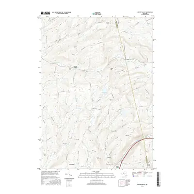
2016 Map of South Valley
USGS Topo · Published 2016About this map
South Valley and the surrounding highlands of the Otsego and Schoharie county line define this corner of New York. The landscape is marked by a high density of small family or local burial grounds, including the Sissum, Winnie, and Ferris cemeteries, reflecting the deep-rooted settlement history of the region. Waterways like Pleasant Brook and Buttermilk Falls cut through the terrain near peaks such as Honey Hill and Pine Mtn. Small hamlets and crossroads like Gothicville, Furnaceville, and Decatur are connected by a network of winding roads, illustrating the persistent rural character of these valleys. The topography is further distinguished by water bodies like Bear Swamp Pond and Plank Pond, which sit amidst the ridges of Elliot Hill and Algerine Hill.
Find a feature on this map
96 named features on this map. Tap any name to fly to it.
Don’t see what you’re looking for? This feature index may not catch every label — zoom into the map to look around manually.
Map Details
Editions of this 2016 South Valley Map
This is the sole edition of this map. No revisions or reprints were ever made.
Other maps of this area

1898 · Canajoharie
USGS Topo · 1:62,500

1900 · Canajoharie
USGS Topo · 1:62,500

1902 · Canajoharie
USGS Topo · 1:62,500

1903 · Richfield Springs
USGS Topo · 1:62,500

1904 · Richmondville
USGS Topo · 1:62,500

1907 · Cooperstown
USGS Topo · 1:62,500

1909 · Cooperstown
USGS Topo · 1:62,500

1943 · South Valley
USGS Topo · 1:24,000

1943 · Sharon Springs
USGS Topo · 1:24,000
1943 · Sprout Brook
USGS Topo · 1:24,000