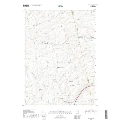
2019 Map of South Valley
USGS Topo · Published 2019About this map
South Valley and the surrounding high country of the Otsego Co and Schoharie Co border define this landscape in the northern Appalachian Plateau. The settlement pattern is largely defined by the drainage of Pleasant Brook and Decatur Cr, with clusters of activity at small junctions like Gothicville and Furnaceville. Local history and genealogy are well-preserved through numerous small family and community burial grounds, including the Sissum Cem, Ferris Cem, and Maple View Cem near Calcutta. The terrain is characterized by prominent rises such as Honey Hill and Pine Mtn, while the southern reaches show the influence of the rail and road corridor along Cobleskill Cr near East Worcester. Natural landmarks like Buttermilk Falls and industrial history at Stone Quarry Hill speak to the area's varied use of its land and water resources during this modern era.
Find a feature on this map
100 named features on this map. Tap any name to fly to it.
Don’t see what you’re looking for? This feature index may not catch every label — zoom into the map to look around manually.
Map Details
Editions of this 2019 South Valley Map
This is the sole edition of this map. No revisions or reprints were ever made.
Other maps of this area

1898 · Canajoharie
USGS Topo · 1:62,500

1900 · Canajoharie
USGS Topo · 1:62,500

1902 · Canajoharie
USGS Topo · 1:62,500

1903 · Richfield Springs
USGS Topo · 1:62,500

1904 · Richmondville
USGS Topo · 1:62,500

1907 · Cooperstown
USGS Topo · 1:62,500

1909 · Cooperstown
USGS Topo · 1:62,500

1943 · South Valley
USGS Topo · 1:24,000

1943 · Sharon Springs
USGS Topo · 1:24,000
1943 · Sprout Brook
USGS Topo · 1:24,000