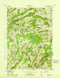
1945 Map of South Valley
USGS Topo · Published 1945About this map
The rugged terrain of the Otsego and Schoharie County line is defined by high elevations like Honey Hill and Roseboom, where scattered family settlements thrived during the mid-1940s. The landscape is dotted with several one-room schoolhouses, including School No 1 near South Valley and School No 9 outside Calcutta, reflecting the rural educational structure of the era. Settlement patterns follow the winding paths of Snyder Creek and Winnie Brook, with small crossroads such as Gothicville and Butler Corners anchoring the upland communities.
Find a feature on this map
41 named features on this map. Tap any name to fly to it.
Don’t see what you’re looking for? This feature index may not catch every label — zoom into the map to look around manually.
Map Details
Editions of this 1945 South Valley Map
This is the sole edition of this map. No revisions or reprints were ever made.
Other maps of this area

1898 · Canajoharie
USGS Topo · 1:62,500

1900 · Canajoharie
USGS Topo · 1:62,500

1902 · Canajoharie
USGS Topo · 1:62,500

1903 · Richfield Springs
USGS Topo · 1:62,500

1904 · Richmondville
USGS Topo · 1:62,500

1907 · Cooperstown
USGS Topo · 1:62,500

1909 · Cooperstown
USGS Topo · 1:62,500

1943 · South Valley
USGS Topo · 1:24,000

1943 · Sharon Springs
USGS Topo · 1:24,000
1943 · Sprout Brook
USGS Topo · 1:24,000