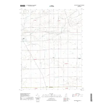
2019 Map of South Whitley East
USGS Topo · Published 2019About this map
The Eel River winds across this section of Northern Indiana, anchoring a landscape defined by its agricultural heritage and intricate drainage network. While the town of South Whitley occupies the western edge, the map reveals smaller historic nodes such as Tunker, Washington Center, and Luther situated near the Whitley Co Huntington Co line. These settlements reflect the late 19th and early 20th-century rural infrastructure, where local life centered around crossroad hamlets and nearby burial grounds like Cleveland Cem and Saint Peters Cem.
Find a feature on this map
66 named features on this map. Tap any name to fly to it.
Don’t see what you’re looking for? This feature index may not catch every label — zoom into the map to look around manually.
Map Details
Editions of this 2019 South Whitley East Map
This is the sole edition of this map. No revisions or reprints were ever made.
Other maps of this area

1950 · Pierceton
USGS Topo · 1:24,000

1953 · Fort Wayne
USGS Topo · 1:250,000

1953 · Muncie
USGS Topo · 1:250,000

1955 · Bippus
USGS Topo · 1:24,000

1955 · Columbia City
USGS Topo · 1:24,000

1956 · Muncie
USGS Topo · 1:250,000

1956 · Fort Wayne
USGS Topo · 1:250,000

1956 · Huntington
USGS Topo · 1:24,000

1956 · Lorane
USGS Topo · 1:24,000
1961 · Servia
USGS Topo · 1:24,000