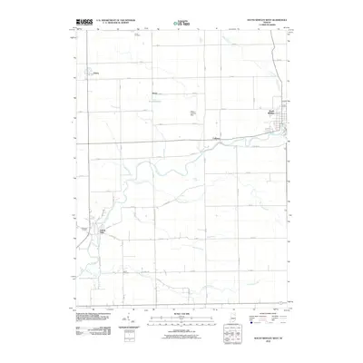
2010 Map of South Whitley West
USGS Topo · Published 2010About this map
The Eel River defines the drainage of this Indiana landscape, winding through a patchwork of agricultural plots and small riverside communities. South Whitley sits at the eastern edge of the survey, where the river meets a grid of local roads and rail lines, while the smaller settlement of Collamer occupies a bend further west. This 2010 depiction reflects the persistent rural character of Whitley and Kosciusko counties, where small unincorporated areas like Kinsey and Liberty Mills remain tied to the surrounding farmsteads.
Find a feature on this map
60 named features on this map. Tap any name to fly to it.
Don’t see what you’re looking for? This feature index may not catch every label — zoom into the map to look around manually.
Map Details
Editions of this 2010 South Whitley West Map
This is the sole edition of this map. No revisions or reprints were ever made.
Other maps of this area

1950 · Pierceton
USGS Topo · 1:24,000

1953 · Fort Wayne
USGS Topo · 1:250,000

1953 · Muncie
USGS Topo · 1:250,000

1955 · Bippus
USGS Topo · 1:24,000

1956 · Muncie
USGS Topo · 1:250,000

1956 · Fort Wayne
USGS Topo · 1:250,000

1956 · Lorane
USGS Topo · 1:24,000

1957 · Warsaw
USGS Topo · 1:24,000
1961 · Servia
USGS Topo · 1:24,000
1961 · North Manchester South
USGS Topo · 1:24,000