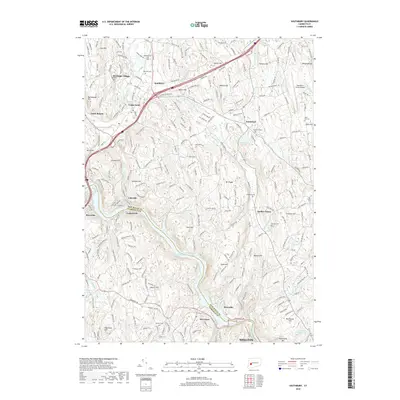
2018 Map of Southbury
USGS Topo · Published 2018About this map
The Housatonic River and the expansive Lake Zoar anchor the southern portion of this region, where the New Haven and Fairfield County line meets. Near the dam at Stevenson, the landscape transitions from the river valley to the clustered settlements of Southbury and Heritage Village. The map reveals a high density of ancestral sites for genealogists, including Pine Hill Cem, Middleground Cem, and Brookside Cem. Industrial and community history is evident in names like Papermill Pond and the Waterbury-Oxford Airport on the eastern plateau. The terrain is defined by numerous family-named peaks such as Georges Hill, Ichabod Hill, and Osborn Hill, while the Pomperaug River and Eightmile Brook provide the primary drainage for the northern hills. Smaller communities like Southford, Quaker Farms, and South Britain are well-delineated among the complex network of brooks and reservoirs.
Find a feature on this map
61 named features on this map. Tap any name to fly to it.
Don’t see what you’re looking for? This feature index may not catch every label — zoom into the map to look around manually.
Map Details
Editions of this 2018 Southbury Map
This is the sole edition of this map. No revisions or reprints were ever made.
Other maps of this area

1889 · Derby
USGS Topo · 1:62,500

1891 · Derby
USGS Topo · 1:62,500

1892 · Danbury
USGS Topo · 1:62,500

1892 · New Milford
USGS Topo · 1:62,500

1893 · Waterbury
USGS Topo · 1:62,500

1893 · New Milford
USGS Topo · 1:62,500

1893 · Derby
USGS Topo · 1:62,500

1904 · New Milford
USGS Topo · 1:62,500

1904 · Waterbury
USGS Topo · 1:62,500

1904 · Litchfield
USGS Topo · 1:125,000