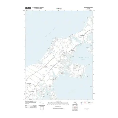
2010 Map of Southold
USGS Topo · Published 2010About this map
Horton Point Light stands as a sentinel over the northern shore of the North Fork, where the land narrows between Long Island Sound and Little Peconic Bay. This era of the landscape is defined by its deep agricultural roots and established maritime character, featuring a dense concentration of local estates and vineyards. Genealogical interest is particularly high here, with numerous historic burial sites such as the Old Burying Ground near Cutchogue and the First Presbyterian Church Cemetery in Southold. The map reveals an intricate network of creeks and necks, from the residential enclaves of Beixedon Estates to the waterfront at Founders Landing. The presence of Pindar Vineyards, Lenz Vineyards, and Wickhams Fruit Farms illustrates a modern economy still tied firmly to the soil, even as coastal developments like Reydon Shores and Laughing Waters mark the shoreline.
Find a feature on this map
94 named features on this map. Tap any name to fly to it.
Don’t see what you’re looking for? This feature index may not catch every label — zoom into the map to look around manually.
Map Details
Editions of this 2010 Southold Map
This is the sole edition of this map. No revisions or reprints were ever made.
Other maps of this area

1903 · Sag Harbor
USGS Topo · 1:62,500

1903 · Riverhead
USGS Topo · 1:62,500

1904 · Sag Harbor
USGS Topo · 1:62,500

1904 · Shelter Island
USGS Topo · 1:62,500

1904 · Riverhead
USGS Topo · 1:62,500

1943 · Riverhead
USGS Topo · 1:62,500

1946 · Sag Harbor
USGS Topo · 1:24,000
1947 · Orient
USGS Topo · 1:24,000

1947 · Mattituck
USGS Topo · 1:24,000

1947 · Mattituck Hills
USGS Topo · 1:24,000